


Britain’s libraries and institutions are being called on to save from export a unique collection of 18th and 19th century charts that document Britain’s rise to become the world’s leading maritime power
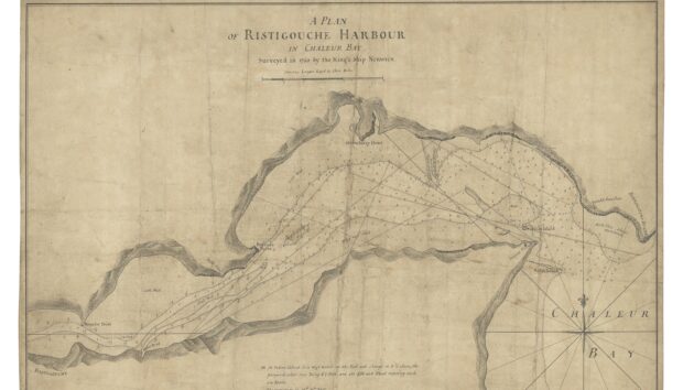
The extraordinary collection, which includes the first chart drawn by Captain James Cook, has been barred from export to allow time for a UK gallery, museum or institution to acquire it.
The historic archive of Imray, Laurie, Norie and Wilson has been valued at £6 million. It comprises the sea charts drawn in the late 18th and 19th century by famous British navigators and explorers.
It represents an important source of knowledge relating to the rise of the East India Company and the emergence of the British empire.
Global maritime power
‘This extraordinary collection helps us better understand Britain’s transformation into a global maritime power,’ said Arts Minister, Sir Chris Bryant.
‘I hope that a museum or institution can come forward to help secure this collection for future generations so that researchers and the public can learn about this crucial chapter in British history.’
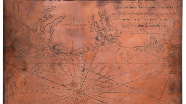
Original engraved copper printing plate of a chart of the west coast of Newfoundland, the fourth in Captain James Cook’s sequence of surveys of the vast coastline of Newfoundland. It was engraved by James Larken in 1768 as a direct commission from Cook.
The collection was sold this year by Imray to map specialists Daniel Crouch Rare Books and Altea Gallery who then agreed a sale to a US private collector.
An export licence was applied for to take the collection overseas but the independent Reviewing Committee on the Export of Works of Art and Objects of Cultural Interest (RCEWA) recommended the temporary block.
The decision on the export licence application is deferred until November 10 by which time it is hoped a British institution will have expressed an interest.
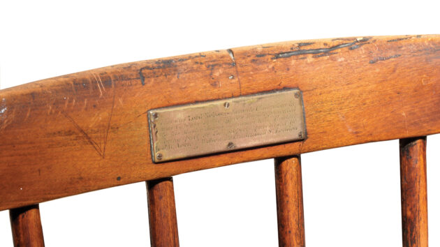
Chair used by Lord Nelson from 1784-87 when he was captain of HMS Boreas, a 28-gun frigate. Nelson sailed her to the West Indies, tasked with enforcing the Navigation Acts, which, in theory, prohibited trade between the US and the West Indies
The collection spans over 200 working charts and 24 rare maritime atlases in their original ‘blueback’ bindings.
It includes unique artefacts such as a copper plate for an original chart by explorer James Cook and a chair used by Lord Nelson from his time as captain of HMS Boreas from 1784-87.
There is also an 18th century manuscript of Bernard Roman’s chart of Florida, later used to locate a sunken Spanish galleon full of treasure.
The collection also has charts documenting the infamous ‘Middle Passage’ route between West Africa, the West Indies, and the Americas – the route taken by the slave ships across the Atlantic.
Captain Holland’s 18th century charts of the northeastern US coast are also part of the archive.
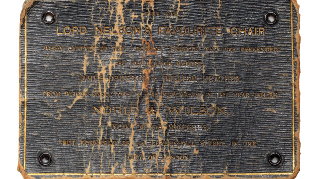
The label on the chair used by Lord Nelson from 1784-87 when he was captain of HMS Boreas
Caroline Shenton, RCEWA Committee member, said: ‘Britain’s position as a global superpower in the 18th and 19th centuries was in large part due to its dominance at sea.
‘For this, the Royal Navy and merchant shipping relied on accurate maritime charts of the world’s oceans and far-flung coastlines.
‘This incredible archive, the surviving records of the premier chart-making firm and its predecessors of Imray, Laurie, Norie, and Wilson, sheds light on one of the principal means by which Britannia ruled the waves for several centuries.
‘It is my fervent hope that a suitable home in the UK will be found for this outstanding, beautiful and fascinating collection.’
Britannia rules the waves
The four main chart publishers of the previous century, Imray, Laurie, Norie and Wilson Ltd, joined forces in 1904 in response to legislation mandating the use of Admiralty Charts for all vessels sailing under the British flag.
This consolidated nearly the entire private sector production of maps, atlases, instruments, and sailing directions under one umbrella.
Daniel Crouch spoke to YM about the collection, explaining that the Admiralty based its first charts on these historic charts. ‘Whilst we have arranged the sale of the archive, Altea Gallery and Daniel Crouch Rare Books did not oppose the temporary export ban. In fact, we would be delighted if the maps were to remain in the UK.’
Lucy Wilson, MD of Imray, Laurie, Norie & Wilson told YM: ‘This is the next chapter in the long and fascinating story of these charts. We wish them well on their voyage!’
Organisations or individuals interested in purchasing the panel should contact the RCEWA on 02072680534 or rcewa@artscouncil.org.uk.
Enjoyed reading this?

A subscription to Yachting Monthly magazine costs around 40% less than the cover price, so you can save money compared to buying single issues.
Print and digital editions are available through Magazines Direct – where you can also find the latest deals.
YM is packed with information to help you get the most from your time on the water.
-
-
- Take your seamanship to the next level with tips, advice and skills from our experts
- Impartial in-depth reviews of the latest yachts and equipment
- Cruising guides to help you reach those dream destinations
-
Follow us on Facebook, Twitter and Instagram.
Note: We may earn a commission when you buy through links on our site, at no extra cost to you. This doesn’t affect our editorial independence.